
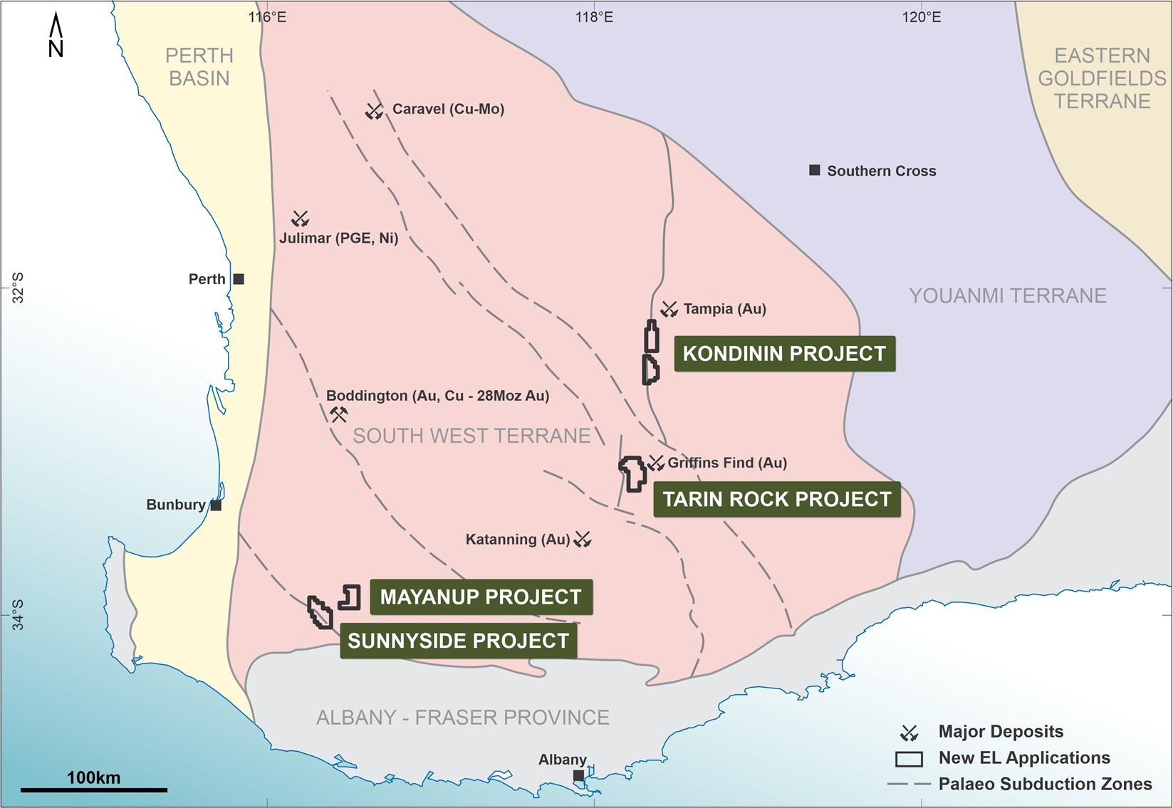
| Figure 1 Location map showing the five south west Western Australia exploration licence application areas. |
Licences have been granted across three areas; the Kondinin, Tarin Rock and Sunnyside-Mayanup projects, each of which is considered prospective for large porphyry Cu-Au deposits and/or intrusion related orogenic gold deposits (Figure 1).
The Sunnyside-Mayanup and Tarin Rock projects are located close to major crustal scale lineaments believed to represent palaeo-subduction zones that may be spatially related to large-scale porphyry deposits such as Boddington and Caravel (Calingiri). The Kondinin Project straddles a major N-S fault zone which links a palaeo-subduction zone with the terrane boundary between the South west Terrane and the Youanmi Terrane, and which is considered prospective for intrusion related orogenic gold mineralisation (refer Figure 1 and refer to Company ASX release dated 22 October 2020).
Sunnyside-Mayanup Project
Two exploration licences have been granted: Sunnyside (E70/5614, 57 graticular blocks), and Mayanup (E70/5613, 40 graticular blocks). These licences occur on flexures in regional structures which are interpreted to represent old subduction zones that may be prospective for porphyry Cu-Au mineralisation.
Sunnyside E70/5614 straddles a structure which represents a sub-terrane boundary. On the northern side of this structure, regional geological mapping indicates the presence of hornblende-bearing quartz monzonites which are locally porphyritic in nature. These types of rocks are considered prospective for porphyry Cu-Au mineralisation. This is supported by strong geochemical anomalism for copper in the CSIRO-CRC-LEME Laterite Geochemical database in this area, with anomalous samples (>100ppm Cu) containing up to 409ppm Cu over an area of ~14km x 3.5km (previously reported on 22 October 2020).

| Figure 2 Sunnyside and Mayanup licences on an image of regional aeromagnetic data, also showing the location of CRC-LEME laterite samples and copper assays for these samples. |
Mayanup E70/5613 straddles two linear structures and contains copper anomalism up to 352ppm Cu over an area of ~12km x 5km (Figure 2).
Tarin Rock Project

| Figure 3 Tarin Rock exploration licence outline on regional aeromagnetic data showing a complex series of nested felsic intrusions near a major jog along a NNE trending fault. |
The Tarin Rock project comprises a single exploration licence (E70/5615), covering 70 graticular blocks. This project occurs in an area of geological complexity where regional aeromagnetic data indicates the presence of a series of complex, nested felsic intrusive rocks to the immediate north-east of a jog in a major NNE trending structure (Figure 3). The Griffins Find intrusion related orogenic gold deposit occurs a further 5km to the NE of the tenement application. Tarin Rock is considered prospective for intrusion related orogenic gold deposits.
Kondinin Project
The Kondinin Project consists of two exploration licences, E70/5611 (Kondinin North, 9 graticular blocks) and E70/5612 (Kondinin South, 39 graticular blocks). The licences cover deformed felsic gneisses to the east of a major N-S structure in which several elongate dome or “eye†structures are present (Figure 4).
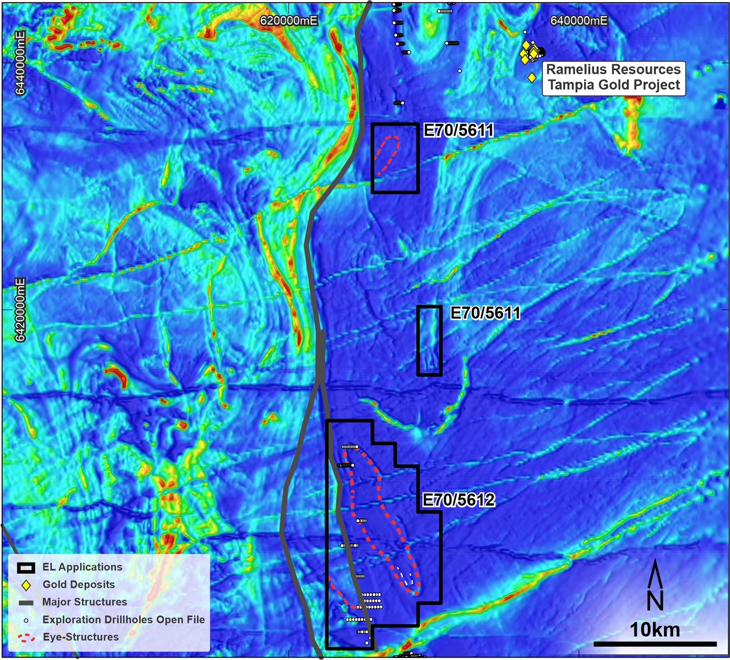
Kondinin North is approximately 10km to the SW of Ramelius Resources’ Tampia gold project. Limited aircore drilling over Kondinin South is reported in open file data.
| Figure 4 Kondinin exploration licence outlines on regional aeromagnetic data showing a series of domed (“eyeâ€) structures immediately east of a N trending major fault |